
Commercial Drone Roof Surveys – UK Wide
Evidence-ready roof imagery without scaffolding, ladders, or disruption.
Ideal for surveyors, facilities teams, property managers and contractors across the UK.
- High-resolution roof imagery for clear defect evidence
- Same-day images and optional 4K video covering 100% of your asset
- Identify potential defects before arranging costly access
- Shareable evidence pack for reports, contractors and insurers
- Optional 3D model / point cloud for complex assets
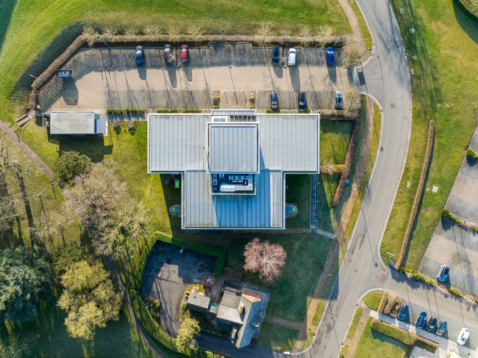
Roof inspections without the access headaches
Traditional roof inspections can be slow, disruptive and risky — especially on warehouses, schools, retail units, offices, and multi-storey sites. A drone roof survey captures high-resolution imagery quickly so you can make decisions sooner, backed by clear evidence.
Why clients book us:
- Pre-lease / Dilapidations evidence
- Planned preventative maintenance (PPM)
- Storm damage / Insurance documentation
- Leak investigation support
- Checks before purchasing, refurb, or solar installs
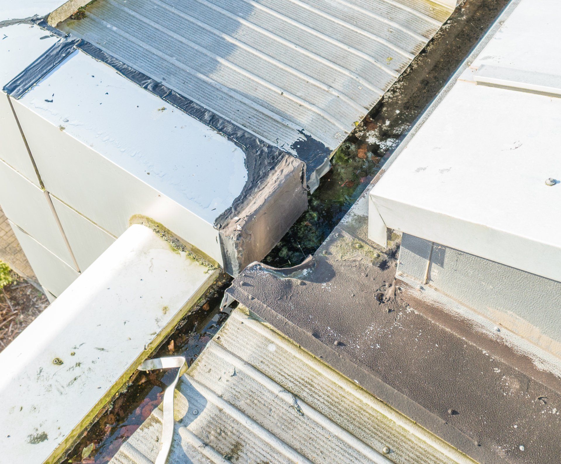
What we capture during a drone roof survey
We tailor each flight plan to the building and the questions you need answered. Depending on roof type and access constraints, we can capture:
- Overall roof condition coverage imagery
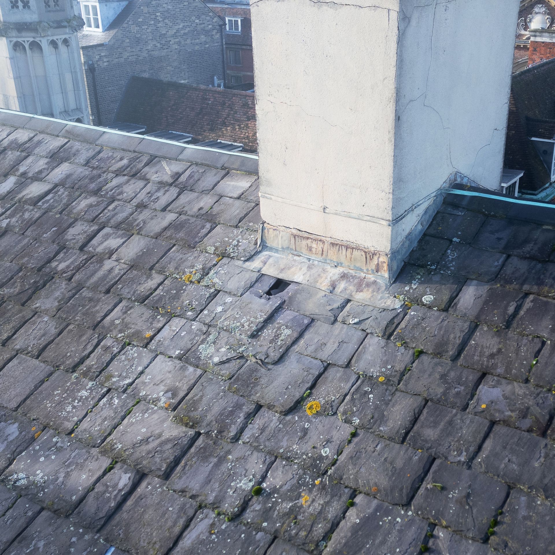
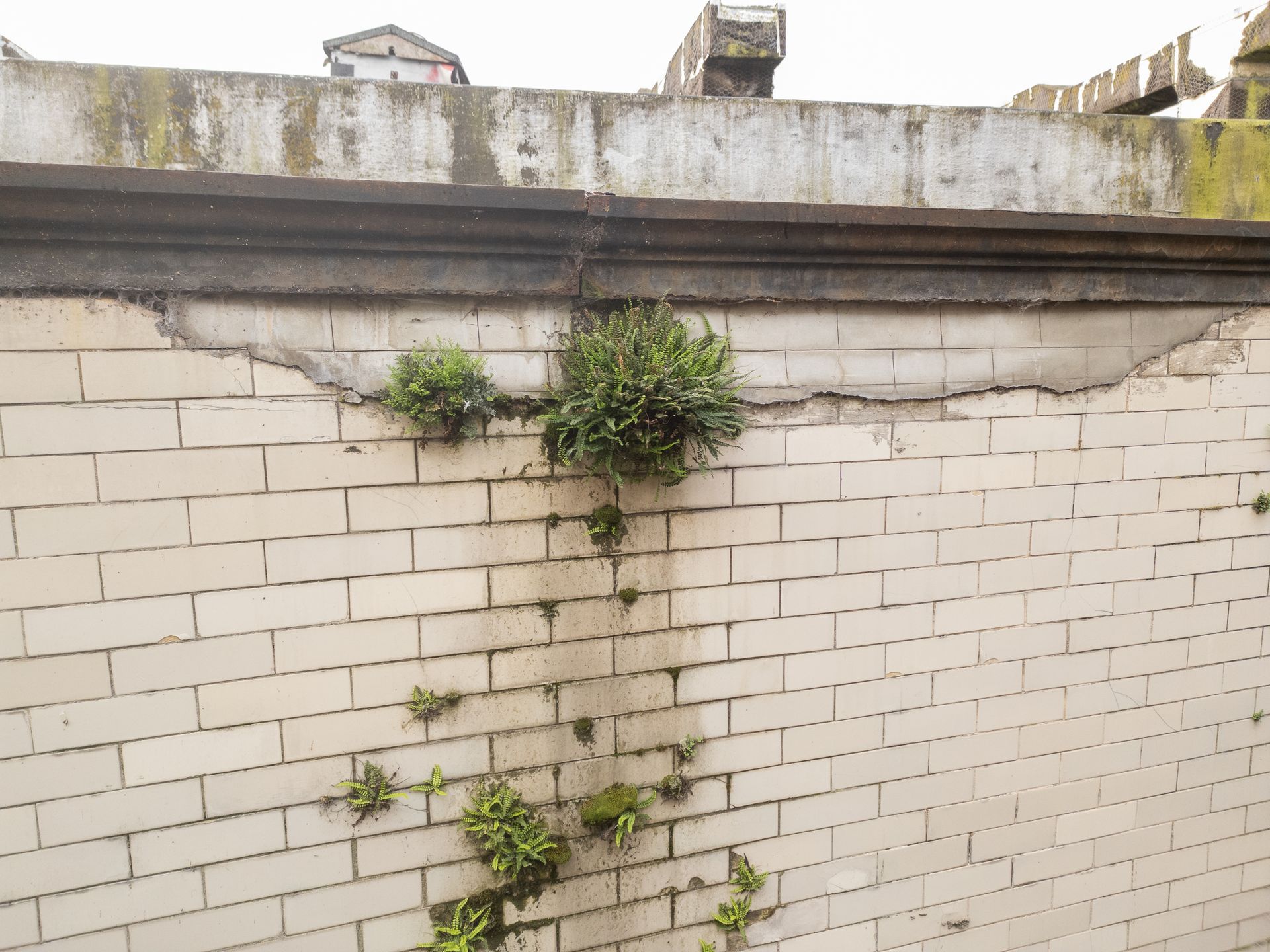
- Close-up defect evidence (failed laps, splits, punctures, ponding, damaged flashings)
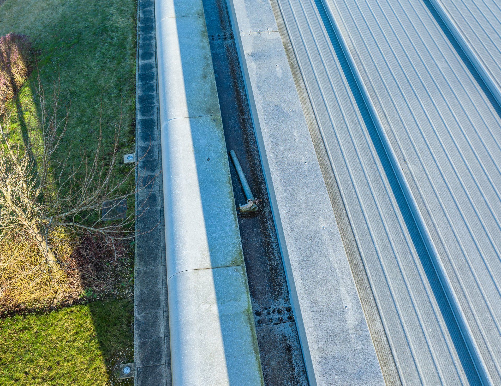
- Gutters, valleys, outlets and drainage routes
- Parapets, coping stones, rooflights and plant areas
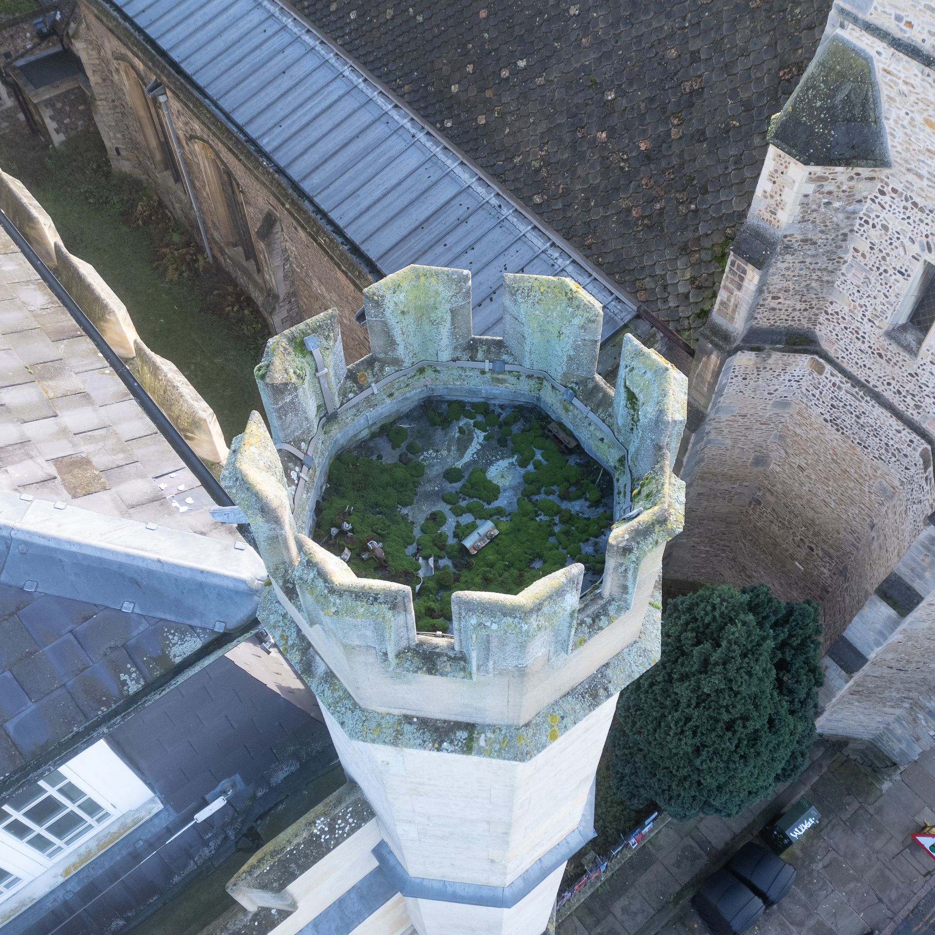
- Chimneys and leadwork details (where applicable)
Drone Roof Survey and Inspection Experts
At Skytech Cambridge, we specialise in providing professional drone roof surveys and drone roof inspections to help you maintain your property with minimal disruption. Our drone technology captures high-quality imagery and thermal data quickly and efficiently, eliminating the need for traditional scaffolding or manual access. This approach not only improves safety but also saves you time and resources in comparison to conventional methods.
Every inspection is carried out by our experienced, certified pilots, who ensure accurate data collection and compliance with relevant regulations. By examining the imagery and thermal data, we provide clear insights into the overall condition of your roof, enabling you to address any areas that may require attention before they become more serious.
Whether you own a commercial building or a residential property, our drone roof inspections can be tailored to suit your specific needs.
See how this supports heritage and conservation.
Ditch the Cherry Picker: Cut Costs with Drone Roof Surveys
If you’ve ever had to rent a cherry picker, you know how quickly expenses can add up—equipment rental, extra crew, and potential road closures.
Drone roof surveys eliminate the need for bulky machinery and complex logistics, saving you time and money right from the start. Our streamlined approach not only reduces manpower and setup costs but also allows for swift, detailed inspections without compromising on safety or quality.
By choosing drone technology over cherry pickers, you’ll keep overhead low and results high, making it a cost-effective solution for both commercial and residential properties.
Enhancing Client Safety: Eliminating Risks of Working at Height
By removing the requirement for scaffolding or other manual access equipment, as well as the risks associated with working at height, we can safely and efficiently capture highly detailed, accurate and repeatable data for our clients.
Every job involves a stringent risk assessment to ensure that all members of our knowledgeable and CAA qualified team; our client's team and members of the public; are safe at all times while we work.
All projects operate with a minimum of £5m public liability insurance as standard.
Frequently Asked Questions (FAQ)
What does a drone survey or inspection involve?
We plan and execute a safe, compliant flight to capture high-resolution, geo-tagged stills and Ultra High Definition video tailored to your asset and scope.
Before flying, we complete task-specific RAMS, airspace checks, and site coordination.
Typical coverage by asset type includes (as relevant):
- Building envelopes: roofs, façades, parapets, flashings, gutters, rainwater goods, rooflights, canopies, mansafe systems, guardrails, ladders, plant upstands, fixings, joints and interfaces.
- Commercial / industrial sites: cladding systems, loading bays, dock levellers, yard surfacing, thresholds, expansion joints, perimeter fencing, signage, service yards and external MEP plant.
- Retail / mixed-use: atria glazing, entrance canopies, signage structures, façade panels, soffits, brise-soleil and weathering details.
- Residential / high-rise / PBSA: balconies and balustrades, façade panels, window assemblies, copings, rainwater discharge points, podium decks, terrace finishes and access routes.
- Public & education estates: roofs and façades to schools, hospitals and leisure centres; skylights, curtain walling, over-sailing canopies, plant screens and service penetrations.
- Transport & infrastructure: bridge decks, parapets, soffits, bearings, expansion joints, abutments, retaining walls, multi-storey car park decks and ramps (subject to permissions).
- Energy & utilities: solar array modules, racking, cable management, inverter housings, substation enclosures, ventilation louvres, access platforms and perimeter security elements.
- Telecoms & masts (external visual): antenna mounts, feeder runs, brackets, cable trays, cabinets and earthing connections (subject to site rules and RF safety).
- Heritage & specialist structures: stonework, cornices, pinnacles, spires, leadwork, chimneys, clock towers, monuments and delicate architectural features.
How does your construction experience benefit inspections?
Our team has extensive hands-on experience working with contractors, surveyors and asset managers. That background helps us anticipate what matters on a live site, frame the right details, and identify visible defects efficiently—e.g., missing or displaced tiles, slipped flashings, failed sealant lines, ponding, cracked masonry, spalled concrete, corroded fixings, poorly seated gutters and damaged cladding elements.
What types of structures and sites do you inspect?
We support a wide range of built assets, including:
- Commercial & industrial: warehouses, distribution hubs, logistics centres, factories, data centres, power stations, water treatment works.
- Retail & mixed-use: shopping centres, retail parks, hospitality, multi-use developments.
- Residential & PBSA: apartment blocks, high-rise towers, student accommodation, build-to-rent schemes.
- Public & education: hospitals, schools, universities, libraries, leisure centres.
- Transport & infrastructure: bridges, viaducts, rail assets (non-operational areas subject to permissions), highways structures, car parks.
- Energy & utilities: solar arrays, substations, telecoms towers and wind turbine bases
- Heritage & specialist: churches, spires, listed façades, monuments, chimneys, atria, glazed canopies and complex roof geometries.
What deliverables will I receive?
A curated visual “findings pack” tailored to your scope, typically including:
- High-resolution, geo-tagged image sets (organised by elevation/area).
- Ultra High Definition inspection video clips focused on priority locations.
- Optional photogrammetry outputs (e.g., orthomosaic imagery and basic 3D models) where appropriate.
All assets are supplied via secure transfer with clear file naming that maps images to locations.
How long does it take on site and to receive the media?
Most single-building roof/façade inspections take 30 minutes to 2 hours on site. Turnaround for media delivery is typically same day or next business day, depending on scope and any optional outputs (e.g., photogrammetry).
What level of detail and accuracy can we expect?
We plan flights to achieve an inspection-grade Ground Sample Distance (GSD) suitable for visual defect identification—commonly 0.5–2.0 cm/pixel depending on height and airspace. Still imagery is captured on high-resolution sensors, and Ultra High Definition footage provides crisp, reviewable sequences for handovers and audit trails.
Can you stream the inspection live?
Yes. We can provide secure live viewing for stakeholders, enabling real-time oversight and rapid decision-making without the need to attend site.
How do you ensure safety and compliance?
We operate under UK CAA regulations with experienced, qualified pilots. Each job includes a task-specific risk assessment and method statement (RAMS), airspace checks, and, where necessary, local notifications/consents. We maintain £5 million public liability insurance (higher on request) and manage on-site exclusion zones and briefings.
What are the typical limitations?
High winds, heavy rain, low cloud and nearby restricted airspace can constrain operations. As guidance, most inspections proceed comfortably up to ~20–25 mph wind at height (airframe dependent). Obstructions (dense trees, enclosed voids) and sensitive environments may also limit access. We’ll advise mitigation steps or suitable alternatives.
Do you need scaffolding or roof access?
No scaffolding is required for our aerial work. Where safe and permitted, we operate from ground level or suitable take-off points, coordinating with site teams for exclusion zones and any required traffic or pedestrian management.
How far in advance do we need to book?
We can often mobilise within 24–48 hours, subject to weather, permissions and site requirements. Time-critical works (e.g., post-storm checks, pre-handover snagging) can usually be prioritised.
What about data security and confidentiality?
Project media is stored and shared via secure platforms. Access links can be permission-controlled, and we’re happy to sign NDAs. We retain project data for a defined period to support re-downloads and audit trails, or we can follow your retention policy.
How is pricing structured?
Pricing reflects scope (areas to inspect), complexity (height, congestion, proximity to constraints), any optional outputs (e.g., photogrammetry), travel and mobilisation. We provide clear, itemised quotations so you can select only what you need.
Do you cover the whole UK?
Yes. While based in Cambridge, we routinely deliver inspections nationwide and can coordinate multi-site or portfolio programmes.
Can you work alongside our principal contractor or surveyor?
Absolutely. We frequently integrate with construction teams, building surveyors and facilities managers. Pre-start coordination ensures our capture aligns with your programme, access windows and deliverable standards.
How do we get started?
Share the site address, a brief scope (areas of interest, known issues, deliverables required) and any access constraints. We’ll confirm feasibility, outline the capture plan and provide a firm quote and proposed date.
Our Latest Project Partners


Contact Us For An Immediate Quote
Contact Us
Our Investment
"We continue to invest in the latest and most innovative hardware, software and training for our operators in order to allow us to provide our clients the widest range of services".
- High resolution commercial drones built for Commercial and Industrial applications.
- Photogrammetric topographic surveys.
- 3D Colour point clouds.
- Geo-referenced orthomosaic images.
- 3D Modelling
- Digital surface models (DSM) & Digital terrain models (DTM)
- Thermal imaging
- Environmental and Flood management surveys.
- Full condition reports for all building and asset inspection work.
- Full interactive 3D Maps of construction sites.
DRONE SURVEY AND INSPECTION FOR ANY TASK

COMMERCIAL SITE SURVEY
NATIONAL HOUSE BUILDER
A recent site-wide drone scan for a new build house developer detected issues which were not immediately obvious from ground level.
The management team were able to work through the comprehensive drone scanned 3D model of the site and the high resolution photos generated by SkyTech Cambridge to identify potential issues. These concerns were then presented to the Site Manager to rectify.
None of this required any time on site and could be carried out from any desktop computer or laptop with an internet connection.
BUSINESS ROOF SURVEY
CHURCH NEAR CAMBRIDGE
On an aerial roof survey at a church in Cambridge, it was identified that some of the brickwork was eroding and falling onto the roof below. In previous years this had caused issues when it had blocked areas of the drainage system.
On this occasion, however, it was obvious that this was not presenting an issue. The remainder of the church's roof was thoroughly scanned, photographed and a full condition report was submitted to the owners for their consideration.
DOMESTIC ROOF SURVEY
PROPERTY IN ROYSTON, HERTFORDSHIRE
A roof survey at a domestic property in Royston revealed a number of issues that the customer decided needed addressing. These were only identified due to the access our drone provided, as the roof area spanned multiple levels, which would have usually required a complex installation of scaffolding simply to carry out an inspection.
Following the survey it was decided to fit a cap to the chimney to reduce the ingress of water as the fireplace is almost never used. They also decided to get the brickwork on the chimney repointed. Work also needed doing to the top of the chimney to rectify the aging and cracking concrete.