
High-Resolution Photogrammetry Elevations for Architects & Surveyors
Time-Saving Photogrammetry Elevations for Architects & Surveyors
Modernise your survey and reporting workflow with high-resolution, scaled orthographic building elevations created from drone photogrammetry.
Designed for architects and surveyors, our elevation outputs provide a clear, consistent visual record of façades and high-level elements — ideal for condition review, refurbishment planning, dilapidations support and stakeholder reporting.
Ideal when programmes are tight and access is difficult — capture high-level façades safely and return a consistent elevation set your team can mark up straight away.
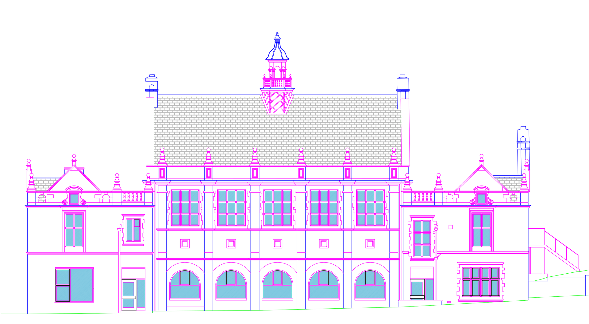
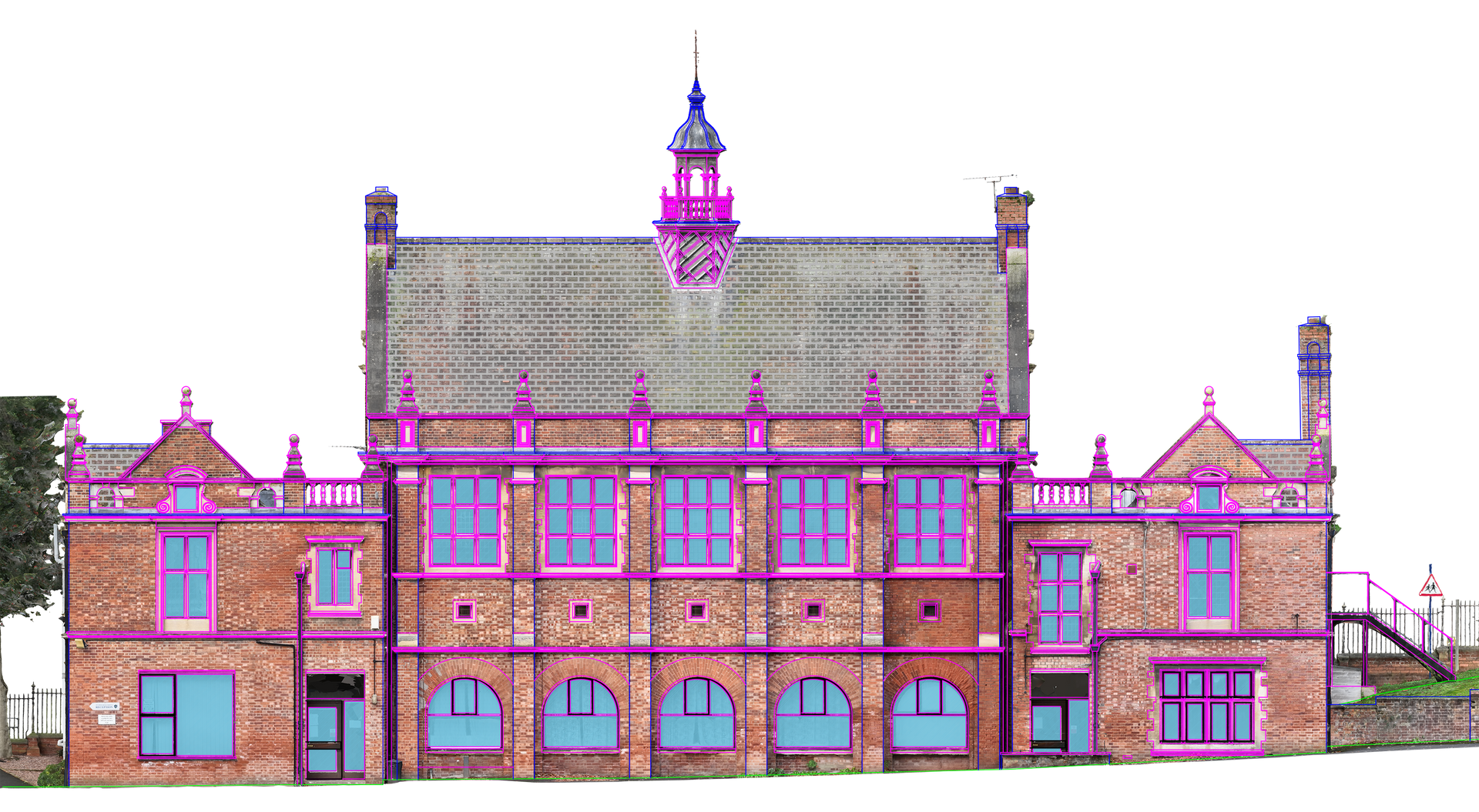
Example Photogrammetry Capture vs Total Station Capture
Drone Capture Time: 3 Hours (all elevations)
Equivalent Total Station Time: 2-3 Days (all elevations)
Time Saved: Priceless
- Reduced time on site (less exposure to weather and fewer access constraints)
- Higher level of detail and coverage across the full façade
- Captures hard-to-see areas that are inaccessible or unsafe to inspect from ground level
- Faster delivery times compared with many traditional elevation capture methods
- High-resolution reference imagery to support defect identification and condition reporting
Elevations built for professional workflows
These aren’t just “nice visuals” — they’re practical outputs created to help project teams work faster and with fewer gaps in information.
- One consistent façade view to mark up, reference and share
- Reduced repeat visits for checks, clarifications and client queries
- Improved coverage of high-level areas without scaffolding for early-stage review
- Better coordination across survey, design, tender and delivery stages
Common use cases
- Overlaying floor plans for planning submissions
- Refurbishment and façade repair planning
- Dilapidations and pre-lease support imagery
- Envelope reviews (visual evidence packages)
- Conservation documentation and stakeholder consultation
- Asset management baseline capture (repeatable for future comparison)
Photogrammetry Elevations FAQs
How is this faster than ground-based elevations?
Traditional elevation capture often means days on site registering large numbers of points—especially on detailed façades. Drone photogrammetry can typically capture the exterior in hours, with processing handled off-site.
Are the elevations correctly scaled?
Yes. We produce scaled orthographic outputs, and if you need higher confidence for measurement, we’ll agree the appropriate scaling/control approach during planning.
Can we take measurements from the elevations?
You can measure from them when they’ve been scaled inside your chosen CAD software. We supply you with the correct scaling parameters which you then configure in drawing software like AutoCAD.
What do we receive at the end?
Typically: a set of high-resolution orthographic elevations (by façade) and an optional companion 3D model link. We can also organise files to match your report/drawing structure.
What file formats do you supply?
We can supply formats suited to review and CAD workflows (for example, high-resolution image formats for easy mark-up). If you tell us your software, we’ll deliver the most practical options.
Can you capture just one elevation, or do we need the full building?
Either. We can target a single façade or produce a full set (front/rear/sides). We’ll advise the most efficient capture plan based on access and site constraints.
Do you need road closures or access equipment?
Usually not. We plan flights to minimise disruption. If a site has constraints (tight streets, heavy footfall, restricted airspace), we’ll advise early and propose a safe approach.
How long does processing and delivery take?
Turnaround depends on building size and the number of elevations/outputs required. We’ll confirm expected delivery times when quoting. Typically, we can deliver most elevation packages within 3-5 days.
What affects the cost?
Main factors are building size/complexity, access constraints, the number of façades, required resolution, and whether you need extras like annotations, close-up ortho sections or a web-viewable 3D model.